Online Availability of Selected Czech Digitized Map Collections in the Czech Republic
Keywords: digital map collections, services, Czech Republic
PhDr. et Mgr. Eva Novotná/ Mapová sbírka a Knihovna geografie PřF UK. Map collection and Geographical Library of Faculty of Science, Charles University; Bc. et Bc. Monika Müllerová / Národní technická knihovna. National Library of Technolog; Bc. Petra Kašparová /Univerzita Karlova. Ústřední knihovna. Depozitář Lešetice. Charles University. Central Library. Depository Lešetice; Alena Šonková / Ústavu informačních studií a knihovnictví UK, student of Institute of Information Studies and Librarianship, Charles University; Mgr. Simona Haraštová / Knihovna Antonína Švehly při Ústavu zemědělské ekonomiky a informací. Library of Antonín Švehla (Institute of Agricultural Economics and Information); Ing. Blanka Smejkalová / Moneta Money Bank
Introduction
Massive digitisation results in changes in activities and work processes within map collections. Using digital technologies enabling efficient presentation and access to cartographic heritage is fundamental for further survival of cartographic collections, which support many educational and research processes, thus relating to a wide range of users. The meta-data models and data exchange standards applied need to comply with users’ requirements for the most efficient, accurate, and multi-layered search results (Šolar 2016).
One of the most important map collections worldwide is the private David Rumsey map collection seated in California. It specializes in rare maps of North and South America from the 18th and 19th centuries and maps of the world (Novotná 2009). It contains 150,000 maps, including precious atlases and globes. It allows digital access to 75,000 items in high resolution with detailed meta-data descriptions. It is possible to search according to categories: what, where, who, when (a map type, the territory displayed, dating). The categories relate to relevant subject indexes. The collection also offers further specialised analytical tools for cartographic works research. Its operators use a number of GIS softwares. The digital repository from the Luna Imaging Inc. company is connected to the geographic search and the Georeferencer software from the Klokan technology company (Rumsey 2017). David Rumsey donated his collection to the Stanford University. Subsequently, a specialised Map Centre was created in the university library. Digital copies are stored in the university’s digital repository. It is possible not only to view, browse, zoom in cartographic materials, but also download them free of charge and without watermarks.
The National Library of Scotland map collection,[1] contains 2 million maps; 200,000 maps have been digitised, out of which 180,000 have been made accessible. All maps are available in the geographical search. Using a bounding box (i.e. a geographical bounding box), the co-ordinates are entered directly into cataloguing entries. The metadata search offers search by the author or cartographer, title and key words. All maps outside editions can be searched according to author, title, date of issue, publishing data, and physical description data. Imagesof maps can be examined using zoom-supporting jpeg 2000 images from the server providing raster data. The graphic tool Map Tiler is also used to display georeferenced map series. There are no watermarks on the maps. An electronic commercial system enables users to order copies or prints of cartographic documents. Among other services used, there is 3D map viewing using the Cesium library, Map Spy viewer, map comparison, web map services, georeferenced maps viewing, a collaborative online map application and map codes sharing on Github (Fleet 2012).
Spain also has its own successful digitised collection[2] in the Catalonian Institute of Cartography and Geology (Institut Cartogràfic i Geològic de Catalunya). Its map collection contains 60,000 items, out of which 12,000 are rare maps. The digital map collection has been in operation since 2007 and provides access to high resolution maps from the 15th century to the present. Since 2014, the CONTENTdm software from OCLC has been used for administration and access to the digitised collections. The Cartoteca Digital’s website provides access to over 20,000 digitised maps sorted into thematic collections. Metadata is exported from librarian formats into metadata formats ISO 19115. The old maps portal displays metadata entries on the left-hand side, and an underlying map for search on the right-hand side. There is a time line at the top allowing a publishing date selection. Search is possible through “Where?”, “What?” fields. Once found, the map is displayed and it is possible to zoom in. The bottom part of the window contains metadate with internet links information. The georeferencing of approximately 1,500 maps was carried out using crowdsourcing under a project with the georeferencer software by Petr Přidal from Moravian Library. Users can further georeference maps (Roset, Pascual, Montaner 2015).
In summer 2016, a pilot questionnaire survey was conducted in digitised map collection in the Czech Republic. The results were presented at the Libraries Today 2016 conference in Olomouc and subsequently published in the proceedings of the same title (Novotná 2016).
The total of 42 digitised collections were examined; they had already contained 375,000 digitised cartographic documents, out of which 274,000 were made accessible. The research was also aimed at aggregated data, particularly into the Digitalisation Register, which is a joint project of the National Library of the Czech Republic, The Czech Academy of Sciences, and INCAD company. The aim of the initial project was to create a national registry of digitised documents, which would serve to control the digitisation workflow of individual institutions and projects to avoid duplication and to facilitate sharing of the results of digitization. In summer 2016, The Digitisation Register registered 32,761 cartographic works, mainly from the Map Collection of the Faculty of Science, Charles University (Novotná 2016).
In the autumn of the same year, a research into access provision and other services connected to digitized map collections commenced within a project seminar at the Institute of Information Studies and Librarianship at the Faculty of Arts, Charles University( ÚISK FF UK). Only Czech collections containing printed documents and their digitized copies were studied. The research did not deal with originally digital cartographic materials (i.e. born digital).
Based on the pilot research, the following collections were selected: 4 largest Czech map collections and 1 virtual collection, where particularly the following parameters were monitored: accessibility using common softwares and technologies, search options, metadata, their types, extent of unification within the portal, and indexation, or as the case may be, relations to authorities. Furthermore, these were also the quality and image loading speed in 2D and 3D, work with acquired data, their downloading and storing, openness and closeness of the portal and their reflection in the number of accesses and the use of the portal use. Finally, these were extra user services and protection of copyright, licence and organization rights.
The monitored collections included collections connected to their own cartographic documents (Central Archive of Surveying and Cadastre, Map Archive of the Czech Geological Survey, Map Collection of the Faculty of Science, Charles University, Moravian Land Archives) on one hand, and the Virtual Map Collection of the Research Institute of Geodesy Topography and Cartography, on the other. The institute does not own a map collection; however, it presents digitized cartographic materials borrowed from other collections.
The text below describes the research results.
1 Archive Maps of the Central Archive of Surveying and Cadastre
The Central Archive of Surveying and Cadastre (later on ÚAZK) administrates about 500,000 map sheets[3]. By half of 2016 the Archive had digitized 130,000 maps (30% of the collection) and made accessible 65,000 of them in the jpeg format in the resolution of 300 DPI on the portal Archive Maps (Novotná 2016). Just in 2015 73,831 maps were scanned, which demonstrates that the digitalisation belongs to the priorities of this institution (The Central Archive of Surveying and Cadastre 2016).
The application Archive Maps provides a quick search for archive maps through the map chart. Apart from its own documents it makes accessible the Indicatory Sketches of the Stable Cadastre administrated by the National Archives in Prague, Moravian Land Archives in Brno and Land Archives in Opava (Central Archive of Surveying and Cadastre 2017).
On the main page a user can select from several types of products that can be searched through. The basic service is a Simplified Selection of Archival Documents. This interface contains the base map of the Czech Republic, which can be zoomed in or switched into an orthophoto[4] image. In the right column a user can select from map layers. After clicking on any spot on the map, a window with the selection from scanned archive documents of the related area is opened (Central Archive of Surveying and Cadastre 2015).

Fig. 1 The display of searches in simplified selection of archival documents. The page with the choice of scanned archival documents of the area Zběř. Selection of topographic sections (1:25 000) and special maps ( 1:75 000) of the 3rd Military Survey from 1872 – 1953 and also of topographic map in the system S-1952 from 1951-1971. In the column on the right it is possible to choose a base map of the Czech Republic or orthophoto. (Source: http://archivnimapy.cuzk.cz/uazk/pohledy/am_main_102067_17.html)
The second product accessible on the web is the Stable Cadastre. In its interface we can select from three grid base maps, which can be arranged in layers (The Central Archive of Surveying and Cadastre 2015).
In the left top corner of the browser there is a list that makes switching among particular collections and applications (for example application Geonames[5], indicatory sketches or selections of any scales) easier. The vertical bar enables zooming out and in, return, selection of an area by a point or rectangle or update of the page. The link to a print of an auxiliary map cut-out of a base map is available as well. There is also the display of the web address (URL) of a site. With the help of the WMS service[6] it is also possible to display orthophotos, building plots and cadastral numbers. By selecting the field “guidelines" in the bottom bar of the browser the user is redirected to the site with 17 video- manuals[7].
The browser of the interface, which makes the 3rd Military Survey accessible, provides similar options as the section for the Stable Cadastre. The specifics of the military survey lie in the selection of scales and map layouts of the base map that correspond to each other (for example, the map layout 1:75 000 or 1:25 000 corresponds to the map of the identical scale). The orientation is made easier by the base map of the 3rd Military Survey from the end of the 19th century. The search outcomes can be converted into the pdf, xls or txt formats (Central Archive of Surveying and Cadastre 2015).
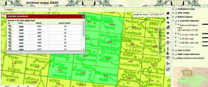
Fig. 2 The map layout with the outcomes of search for scanned maps in the 3rd Military Survey in the scale 1:75 000. Through the selection by a point or rectangle a table is displayed with a scanned archival document and the possibility to convert the results into the formats xls, txt or pdf.
The fourth outcome of the Archival maps is Topo S-1952[8]. They are topographic maps in the S-52 system with a complete series 1:10 000-500 000.
Further the digitised state maps - derived SMO-5 (i.e. basic map set of a large scale,
1:5000) are made accessible. There is an option in the browser to switch off the base map.

Fig. 3 A table with outcomes of a selected map in the scale of 1:200 000 in Topo S-1952. The green watermarks V©ČÚZK are used. The choice of an area is carried out by a point or rectangle. It is possible to export the outcomes of search into the formats xls, txt or pdf.
The state maps - derived are made accessible by the page titled SMO-5 where the scanned first editions of map sections of this work are showed. A user will get to the specific map after zooming in the area when colour segmented rectangles of particular nomenclatures are displayed with red watermarks of their titles. The selection of the area is made by a point or rectangle. After the marking a script with the list of searched scanned archival documents and name of the area is displayed. By clicking on an item a digitized document is displayed. Particular map sections are segmented in colours according to the state of digitalisation of the map set (green – scanned, red – has not been preserved, white non-scanned) (Central Archive of Surveying and Cadastre 2015).
The Map of Real Estate Registration is behind the application with the acronym MEN. In the browser one can choose either MEN of Bohemia or MEN of Moravia and Silesia. The segmentation of sections is colour according to the edition and the state of digitisation (yellow – more editions, green – one edition, pink – non-scanned). MEN contains selection of 12 scales in its scroll offer.
Collection I. is a list of scanned cartographical archival documents, which are indexed for searching in the index The maps are dived into three parts (Maps of Bohemia, Areas Abroad, Street Maps), which one can browse through. An index of names, themes and area is a part of the file. They refer to inventory lists that are available in the reading room of the archive.[9] Particular scans are available for purchase through the e-shop.[10]

Fig. 4 An example of browsing with previews of the Collection I. Below the previews descriptive metadata of particular scanned archival documents is displayed. On the top left there is a reference to a name, thematic or area index.
(Source: http://archivnimapy.cuzk.cz/cio/data/sbirka_I/_menu/sbirka_I_bohemika_seznam_nahl_temp_03_01.html)
The institution also publishes the maps issued after 1946 as it is the administrator of copyrights and licence rights. It is, therefore, the provider of an author licence. Particular base maps of those times in the browsers are provided with a green watermark ©ČÚZK, which is randomly generated all across the whole map. After opening there is numerical information about the origin and authorship of the map in the digital copies of maps. For the access to full maps without protective marks a user goes to the e-shop where he fills in the Contract for the Provision of a Digital Product and according to the price list[11] he buys a licence for the use of the work[12].
2 Map Archive of the Czech Geological Survey
The Map Archive of the Czech Geological Survey (later on ČGS) contains about 32,000 printed maps, about 25,000 manuscript maps and 160 atlases. Further it contains graphic and text supplements to maps (about 21,000). In total the archive registers 78,860 unique documents. Together with duplicates and various variants the collection contains about 102,600 cartographical documents. As for 15 August 2016 more than 74,672 cartographical items were digitised (Novotná 2016).
ČGS makes these documents accessible freely and free of charge through information services and applications on its map portal (http://www.geology.cz/extranet/ma-py/mapy-online). As ČGS is a publisher and licence holder, the digital archive makes accessible also more recent works, which are protected by the Author´s Act.
We can browse through the data of the digitized cartographical documents of ČGS in several various ways. Through Digital Map Archive of ČGS, through National Geoportal INSPIRE (INfrastucture for SPatial InfoRmation in Europe)[13] and also through the applications made in ČGS. The above-mentioned applications are accessible directly from the web interface without any necessity to install new softwares .
Working on the ČSG portal is simple and intuitive, user´s guidance is excellent. The searching forms are clear and comprehensible, further processing of results is also easy. Neither identification nor authorisation of a user is necessary for operation of the portal.
The Digital Map Archive of ČGS enables several ways of search. First it is a quick search in the fields theme group, year of issue, author, displayed country or continent and scale. Another possibility is a detailed search according to the theme, title of a map, author, year of issue, time of creation, country or continent, map layout, sheet number, scale, file of documents, signature, barcode, ID of a document, archive, collection and storage. The Digital Archive of ČGS also offers search in the supplements to maps[14] according to their type, title, author, year of issue, country or continent, map layout, sheet number, sheet title, signature and ID of a document.

Fig. 5 Display of descriptive metadata of the sketch of the 30th floor of the Mine Vojtěch by František Kratochvíl from 1950 in the Digital Map Archive of ČGS. In the upper bar a user is noticed that the document does not contain any appendices. (Source: http://www.geo-logy.cz/app/archiv/mproz.php?item=&rowid=106435&tt_=e)
The outcome of the query is a well-arranged list of results, which contains a title of a document, authors, type of a map, scale, country, year of issue and a preview of a map. It is also clearly indicated whether a map contains appendices or explanatory notes. A detail of required document or a map with metadata at the foot including appendices can be displayed from a found search. The maps are made accessible in the jpeg 2 formats with 50% compression from an archive copy.[15] For viewing 2D images the Zoomify software is available, which enables to zoom in and out and shift a map.
In the ČGS portal the application Prostorový archív ČR (Spatial Archive of the Czech Republic)[16] is available too. It searches and displays localised sketches of maps on the base map of the Czech Republic. It is provided with protective watermarks ©ČÚZK. The search is carried out in the fields theme, scale group and spatial limitation (either according to the current cut-out of a map, the sketch itself on the map or administrative unit). The application also provides geographical search on a base map. On the map of the Czech Republic when moving the cursor current co-ordinates and scale are being displayed at the foot left. Detailed search offers a user apart from the above mentioned fields also this: signature, ID of a document, title, authors´ names, year of issue, period of creation, name of the map layout, number of a map sheet, type of a document (for example, manuscript, print, digitised etc.), archive and collection.

Fig. 6 Display of the map of the 30th floor of the Mine Vojtěch in spatial application of the Digital Map Archive ČGS that enables to display cartographical document on topical base map of the Czech Republic. It is provided with the watermarks of ČÚZK. (Source: http://mapy.geology.cz/mapovy_archiv_cr/?dokume3nt_id=106435)
The Metadata Catalogue ČGS called Micka[17] is also at users´ disposal. The system operates with metadata of spatial maps according to the ISO, OGC and INSPIRE standards. It offers contextual help. Within the metadata module it is possible to log in, users can create, import/export and change metadata records according to the level of their rights. The users who are not logged in can search for metadata records in a full-text search, according to the key words (form the thesaurus GEMET[18], 1G-E, themes from INSPIRE[19]), according to geoscientific themes ČGS (types of maps)[20], according to the type of source, according to the limitation of the access to the source and according to the contact person (expert guarantor). Among all the items of the search form logical penetration[21]applies. The metadata is in the .xml format. In the current version of the Digital Map Archive the following standards are supported: Geographical Information-metadata (ISO 19115[22]), metadata of web services (ISO 19119[23]), the catalogue of geo-elements (ISO 19110[24]), particularly the part needed for description of geo-elements of data sets attributes and the metadata Dublin Core[25]. The user´s environment is multilingual, currently it supports 12 languages.
3 The Digital Map Collection of the Faculty of Science, Charles University
The Map Collection of the Faculty of Science, Charles University (later on also PřF UK) belongs among largest universal collections on national and international scale. The collection contains 130,000 map sheets, 3,500 atlases, 250 wall maps, 85 globes and 34 models, plastic maps, then monographs and special and other special documents as well. (Novotná 2016)
When cataloguing documents, the valid national and international rules are followed, i.e. RDA (before AACR2/R) and the format MARC 21. Within the project dealing with new technologies and processing map collections (TEMAP, 2011–2015)[26] apart from other things a number of methodologies for description of special cartographic documents and for creation of metadata (Novotná 2014a; Novotná 2014b; Brůha 2014) were created here. In the Aleph software 56,000 bibliographic records with almost 100,000 items were described as well. 68,000 maps and sheets of atlases were digitized, out of which 65,000 unique pieces of cartographic heritage were published. The bibliographic records are made accessible in the Central Catalogue of Charles University together with the links to the objects placed in the Digital University Repository (later on DUR). From the very beginning DUR was considered provisional as it was not outlined for working with maps. However, it was sufficient for testing works in the first years of the project. In 2015 it even gained the certificate of trusted storage[27] and the number of objects displayed to a user increased up to 500,000 (Novotná, Fenclová 2016). Also a new interface for geographical search was made available.
In 2015 the Digital Map Collection (later on DMS) was launched, which is a specially programmed web application based on mutual integration of the metadata catalogue Geonetwork, database system PostgreSQL and map server Geoserver. It enables to carry out administration of better quality, publishing and searching for metadata and objects in a good quality resolution, working with interactive map and with spatial georeferenced data.
For making the documents from DMS accessible neither login nor registration of a researcher is needed.
On the opening screen the previews of 65,000 maps including titles in a very high quality are presented. They are arranged according to topicality or popularity with users. One can also browse through the records. Researchers can create more complex searches thanks to a full-text search from all selective fields. The search with the help of the co-called key words is of a great importance. These subject and geographical headings were not created at random but within the process of cataloguing they were validated as against the files of national authorities of the National Library of the Czech Republic.
In the upper bar of the portal there is a menu with icons “search” and “help”. By clicking on “search” various kinds of documents filters are opened. All the metadata records are provided with co-ordinates in the MARC 21 034 and 2556 fields just within the process of cataloguing. Therefore, they enable to make geographic searching on a base map. A researcher clicks on the respective tool (the pencil icon) on the top left and marks the required area – subsequently relevant documents are found at once. By clicking this spatial filter can be cancelled.
Into the search line any term from the catalogue field can be written down. Just within the writing down relevant titles from indexes that contain the inserted term or its part are being offered. When searching, it is possible to work with right side masking with the help of characters “?” and “*”. By clicking on three dots next to a magnifying glass a special line for key words is opened. After inserting a term, for example botanic gardens, headings from the index start to be written out. The selection is made by clicking on the selected heading. On the bottom left there is also an offer of maps selection according to scales.
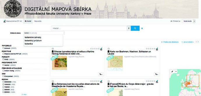
Fig 7 Search that displays selection from terms ”botani?” in the index. (Source: http://mapy2.natur.cuni.cz:8080/geonetwork/srv/dut/catalog.search#/search)
The found map is opened in a separate window in whose heading the data on title and responsibility is placed and just below there are subject and geographical headings. All records of the metadata catalogue are linked with bibliographical description in the Central Catalogue, Charles University. A researcher can display and export them in 6 formats and 10 citation styles. The record also contains an option to view a georeferenced map or to geo-reference it in detail, overlap layers of a new and old map or to display it in the Google Earth application.
By the option open layers the map is displayed in the best available resolution of a very high quality (it is made accessible in the optical resolution of 300 DPI in the format jpeg 2000 in non-loss compression). The water mark is placed only on the bottom right and it does not hinder the image. We can work with the map interactively; it can be zoomed in or out. The current co-ordinates of the cursor are displayed in the bottom right corner.
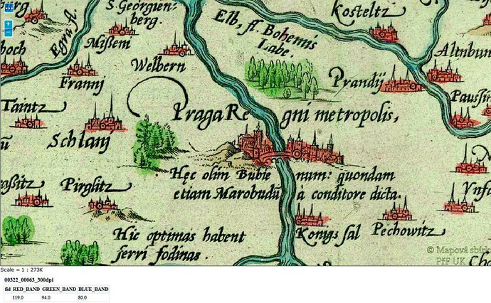
Fig. 8 Detail of the searched map of the Kingdom of Bohemia. The watermark in the right bottom corner does not hinder the image. When zooming in the scale is being recalculated on the bottom left below the map. Below it a signature and depth of colours on the map is displayed where we clicked with the cursor. ORTELIUS, Abraham. Regni Bohemiae descriptio. Scale 1:781 000. 5,4 cm = 6 miliaria. [Antverpiae:] [Abraham Ortelius,] [1588]. (Source: http://mapy2.natur.cuni.cz:8080/geoserver/MapovaSbirka2/wms?version=1.1.0&request=GetMap&layers=MapovaSbirka2:00322_00063_300dpi&styles=&bbox=12.617778000000,48.549167000000,17.292222000000,50.729444000000&width=1300&height=700&srs=EPSG:4326&format=application/openlayers)
The last button offers a download of a map. It is also possible to download it from the preview in the resolution of 100 DPI, which can be sufficient for a researcher particularly at larger works. One can share interesting works on social networks. The atlases are browsed through page by page. Those interested apply for an image of archival quality in the tiff format to the Map Collection and they obtain it on the basis of a licence.[28] For research and study purposes it is for free, for commercial purposes its price is according to the valid price list.[29]
The globes and models are made accessible from the interface of the portal Map Collections in the WebGL format. Also the quality of these images in 2D and 3D is very high (the total volume of a model is 33.5 Mpix) and downloading is fast. It is possible to rotate, zoom in and transfer the 3D models of globes into a map. They are at disposal in georeferenced form as well. Those interested will also find on the web interesting information on restoration, digitisation or on other globe collections.
Fig. 9 An example of the 3D geomorphological model of Gotthard Massif. Gotthard Gipfel und Quellen: Reuss, Rhone, Tesin, Rhein. [Scale unspecified]. 1817. (Source: http://www.mapovasbirka.cz/models/)
A researcher can also download the metadata. It was generated from DUR in the METS[30] standard. The input data were bibliographic records (MARC21 xml[31]) and technical metadata MIX.[32] An important advantage is the possibility of the metadata repair right in the metadata catalogue Geonetwork. Except for an exact title of a document in original language an author, co-authors and year of publishing are presented, if the information is available. The metadata for globes and models is also generated from bibliographic records and is entirely in accordance with the rules of description.
Within the course of work, a help for all types of visualization of cartographical documents is available for researchers.
Copyrights and license rights are respected, the works whose copyrights are free or that have a license agreement concluded with heirs, are published. Such works are stored in separate personal portals accessible from the main portal of the map collection. The entire texts and cartographical documents of important personalities like Karel Kuchař, Jaromír Janka, Anna Dvořáčková and Ludvík Mucha are published. The reproduction rights of scanned works are owned by PřF UK. In an open e-learning course those interested can get to know the methods of scanning, geo-referencing, rules of description and detection of an unknown cartographic projection.[33]
4 Digitized Map Collections of the Moravian Land Archives
4.1 Stable Cadastre - Indicatory Sketches
The Moravian Land Archives (later on MZA) owns 69,000 cartographical documents in total (Novotná 2016). Two digitized parts of the collection were examined: Stable Cadastre and Mining Maps.
The emperor´s edict of 1817 set the new so-called Stabile Cadastre for the purpose of accurate land tax, which was important for assessment of a net gain of land. In 1950 these Indicatory sketches were taken over by the State Archives in Brno and in 2006-2007 they were digitized and made accessible on the Internet (MZA 2016).
The application of the Stable Cadastre is set on the Windows platform (Emmerová 2016). At the same time for accessibility of data a modern web browser is important (MZA 2016).
It can search according to the name of the cadastral area, district or signature but also according to the alphabet. It is sufficient to put into the field Název katastru (Name of the Cadastre) first letters of a chain and the outcome will be all sketches that contain the chain of letters that was inserted. Alternatively, it can search in the catalogue according to initials. The outcome of the search is displayed as a clearly arranged abstract. This list is possible to be arranged alphabetically by left-clicking into the head of a column.
The maps made accessible are of scale 1:2 880, for mountain municipalities scale 1:5 760 is used (MZA 2016). The descriptive metadata is made in the .xml format (Novotná 2016). The scanned maps are made accessible in the jpeg format in the resolution of 400 DPI in 24-bit colour depth (Emmerová 2016). They are provided with protective transparent watermark with the text Moravian Land Archives in Brno extended across the entire window. To view digitized documents, it is necessary to download Flash player in version 9 or higher.[34] JavaScript and cookies must be authorized. By request MZA sends DVD with the maps that were searched up in the same format (jpeg 400 DPI) without protective watermarks (MZA 2016).
Registration of a user is not necessary only in the case he demands extra services like e.g. sending the Indicative Sketches recorded on DVD. Then it is a paid service.[35] The particular nomenclatures of a digital sketch are chosen by clicking on map layout.
Searching for documents is made with the help of icons placed on the left above the maps. They contain symbols: back to search, signature, shopping basket and rough measurement of distance. It is possible to zoom in or to zoom out marked parts of a map or to drift. It is possible to adapt map cut-out to the window both in width and height.

Fig. 10 The detail of the Indicatory sketch from the Pelhřimov district, Horní Vilímeč from 1835. At the top left part there are pictograms for further work with the map. Icon “i” displays basic metadata. At the top right a current cut –out of the map is displayed (Source: http://www.mza.cz/indikacniskici/#)
On the top right a user can find pictograms for price list, orders and help, which are continuously available for a researcher. You can order digital sketches through the e-shop. By clicking on the sketch and activation of the order worksheet window an order is automatically registered. The price of one copy is CZK 25, -. A user can search on the portal in Czech, English and German.
The question of author and licence rights within the Stable Cadastre – Indicatory Sketches is solved in accordance with the Copyright Act. The maps older than 70 years from their publishing or from the death of the last co-author are published. The basic condition for using a document is adherence to the conditions given by an institution. MZA makes accessible about 4,500 Indicatory Sketches of the Stable Cadastre of Moravia of the years 1824 – 1931. The application for making the Indicatory Sketches accessible was launched in 2010 when the first online version was published (Emmerová 2016). The average number of researchers is 2,997 per week. The current statistics show a high rate of use: from 1November to 30 November 2016 the digital maps registered 4,008 entries, 2,443 users and 8,118 displays of the sites (Hejtmanová 2016).
4.2 Mining District Office Brno/II
The Archives of the Mining District Office Brno/II collects cartographic records from the period 1781 – 1959. The mining maps were digitized within 2012 – 2013.
To make the data accessible it is necessary to install Microsoft Silverlight.[36] Then basic searching interface - main window – is displayed for a user. Here detailed information on the inventory is available, which contains basic archive descriptions of 1,456 mining maps (inventory number, signature, content, title, author´s name and publisher´s data, time extent, cardboard box), through which a user can browse. On the right he can have a look at a digitized cartographic document.
The search can be done in four ways: 1. by html inventory application for viewing archival inventories[37]; 2. by the inventory list in pdf with references to applications[38]; by using Silverlight technology[39] and 4. by display of mining maps locations on the portal mapy.cz.[40]
Metadata is based on the description that is binding for archives. The names are rewritten into Czech but the original title of a map is not presented. The description of the portal is unified and integral. Viewing the metadata is enabled by the application for viewing archival inventories.
The maps can be zoomed in and zoomed out, switched on full screen or we can get back to the basic display. The aproximation is highly detailed.
The mining maps in MZA are available for free. The above mentioned dispatching of copies of good quality without a watermark is a paid service.
It is possible to specify searching on the portal mapy.cz according to the raw materials, for example: graphite, granite, clay, kaolin, ceramic clays, copper, oil, lead, silver, sulphur, coal, natural gas, zinc, gold or iron.

Fig.11 Searching for mining maps on the portal mapy.cz in the location of Ledeč nad Sázavou. It is possible to display a current preview of a map as well. (Source: http://www.mza.cz/a8web/A8Apps1/D16/D16-S1-All1.htm)
The application provides contextual help and user manual. MZA makes accessible 1,456 mining maps in total (as for 15 November 2016) (MZA 2016).
5 Virtual Map Collection of the Research Institute of Geodesy, Topography and Cartography
The Virtual Map Collection (VMS) was created by the Research Institute of Geodesy, Topography and Cartography (VÚGTK) as part of the project Cartographic Sources as Culture Heritage from the NAKI programme ran by the Ministry of Culture of the Czech Republic. VÚGTK collaborated with the Institute of History, Czech Academy of Sciences (HIU) on the project, whose map collection contains 6,250 maps and approximately 1,200 atlases[41], of which 2,900 maps are part of the map portal of VMS (VÚGTK 2011–2015). VÚGTK does not own a map collection and therefore the Institute scanned borrowed cartographic material from 31 national and foreign, from private collections[42] as well as from commercial companies. The collaboration was carried out on the basis of abiding to reproduction rights (Novotná 2016). By the end of 2016 on the VMS site, 51,071[43] cartographic and other documents were made accessible; this included 114 globes, 10 map works and 7 atlases. The maps and globes, however, appear in duplicate in the database and it is impossible to find out the number of unique metadata records.[44]
A user can use the VMS portal without the prerequisite of registration or login. It is however recommended to login to benefit from additional add-ons like MapComparer.
The user is able to view 3D models using the plugin, Google Earth. All viewing requirements are found within the help for globes section.[45]
The portal makes primal geographical search on a base map. This function is accessible from the home page. The portal helps to navigate according to the area and then to specify queries according to the date of issue (by a shift along the time line from the year 1200 to 2000) or by selecting the scale of the base map (from 1:100 to 1:7 500 000). After entering the parameters, all relevant documents with preview, name, date of issue and scale are displayed in the column on the right hand-side. After clicking on preview, a new window opens showing a map with full resolution, which can be magnified using the plus or minus function. (“+” and “-“). The displayed map has protective stepped watermarks of VÚGTK and of the relevant legal entity or of the physical person who lent the document to be digitized.
Metadata displayed on the right is of various quality. For example, the National Library of the Czech Republic provides a detailed description of the data, whereas other institutions present hardly any metadata. Secondly, the presented date of issue of a map is often ambiguous. For example, the oldest map in the database, the Klaudyán map of Bohemia, has an issue date of 1518. This would be satisfactory if its owner (HIU) described the original. Nevertheless, here a modern facsimile is presented or maybe only a copy of the map, the real date of issue is missing and the user is not informed about the fact it is a copy nor the details of its publisher.

Fig. 12 A sample of basic geographical searching interface of the VMS portal. The time line was limited for the oldest map on the portal. The Klaudyán map of Bohemia from 1518 was found. Source: http://www.chartae-antiquae.cz/cs/?view=49.99891228081066,14.353637695312498,8&year=1200,1541&scale=100,7500000)
The fragmentation of metadata indexing is demonstrated by the absence of authority links and the insufficient and uncoordinated description of objects. The most considerable difference can be observed with dimensions of maps. Once first height and then width are given, then on the contrary, once in centimetres then in millimetres etc. Uncoordinated indexation of the portal makes it difficult to search and to determine unique records.
The possibility to make georeferenced maps available displays over metadata. VÚGTK takes part in the collaboration with the Moravian Library when old maps[46] are georeferenced. Further services are based on applications that were made accessible. At the displayed map a correction of co-ordinates is offered or the possibility to open it in the MapComparer (see later).
The advanced search option enables searches to be performed according to the title. However, in this field, Boolean operators do not work. This means that all entered words from the title are searched. Another possibility is to search in the field “author”. This, however, is not often filled in uniformly as there is no validated to authorities. For example, first names may be abbreviated or absent. First name and surname may or may not be inverted. In some cases it has dating[47], in others none. Further fields for searching are a year of issue and scale. A user can search according to collections and the type of work (map, globe, other, any) depending on the type of description. For instance, globes are not described under their title but under some kind of formalised simplified title: celestial/terrestrial, author´s or publisher´s surname and a year of issue. For example, when we enter search “Felkl´s Globe Maps” the outcome is found among globes (types of document) although it falls into the class maps. As stated previously, the number of retrieved types of documents does not correspond to the number of documents in particular collections (see appendix).
Using a more complicated search, the researcher does not have the opportunity to search according to the publisher, place of issue or edition and not even according to subject headings, key words or other retrieval languages. It is however possible to search for atlases, globes and map works through the menu in the upper bar of VMS’s introductory website. The globes are arranged by ascending order, according to time (from oldest to youngest) with the above-mentioned simplified description in the heading (type of a globe, author, year of issue), plus 3D or 2D display and metadata describing the year of issue, author, size, collection and annotation.
The 3D globes can be zoomed in using a mouse. It is possible to overlap them mutually and make the layers transparent. Except for the base layer, a researcher can work with orthophoto or boarders of states and continents from Google. The model of the Earth or celestial sky may be unrolled into plane and a map is created from them.

Fig. 13 An example of a detail of visualisation of a star globe and its description on the VMS portal. Star, Blaeu, 1603. (Source: http://www.chartae-antiquae.cz/cs/globes/78452)
Seven atlases are described in the search headings in a different way: they may include the author´s name, year of issue, title or only the word “atlas”. The atlases are presented by year of issue and the name of the collection from which the document comes from and annotation. The sheets are provided with watermarks, it is possible to zoom and browse through them.
It is possible to view the connected map works in the Zoomify application, i.e. a user can zoom in and out. For working with this service, the user is transposed from VMS to the Map Portal of VÚGTK.[48] The Müller´s Map of Bohemia and Moravia, Map of Saxony and Bohemia and topographic and special maps of the 3rd Military Survey[49] contain the georeferenced layer. A researcher can overlap and compare layers of old and new maps. In the column on the right hand-side, the map sets are ordered and in the left hand-sided column selected map works are made accessible or are overlapped. With sliding callipers it is possible to set transparency of a map. The current graphic scale is displayed on the bottom left and it is adjusted to a specific zoom. The displayed set is possible to be zoomed in and out with the + and – buttons or by moving the cursor (the icon in the shape of a hand) and clicking on the displayed document.
Three sets make a 3D model of a map accessible, in which it is possible to view the terrain of a map, rotate it and display exposure of the terrain in various periods of daytime. In total, ten map works processed in this way are available.
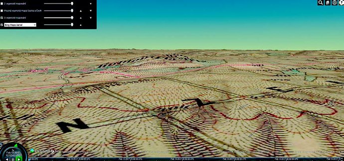
Fig. 14 An example of the 3D models of a map work with terrain visualisation. The Cesium library of the 3rd military mapping was used, original topographic section 1:25 000.[50] (Source: http://www.chartae-antiquae.cz/mapserver/3D/index.php?display=3)
At particular objects metadata is available whose structure differs according to the type of collection and document. The metadata is not always complete nor standardised nor homogenous.
The grids are displayed in the resolution of 600 DPI and are completed with protective watermarks. Downloading and saving a document is not supported by the VMS portal. The authors prepared for users a help[51] for working with maps, map symbols, for viewing globes and for the map viewer MapComparer.
Through the web portal VMS other applications are available as well. The MapComparer enables further comparison and analysis of maps.
The application Map Symbols makes special maps of the 3rd Military Survey[52] accessible (in the resolution of 400DPI) where the map key was processed in such a way that particular symbols could be automatically searched for on this map work. By clicking on a map sheet the application is opened and a researcher selects the symbol on the sheet he is interested in.
The service convert of Zoomify into the web map service (later on WMS) provides a user with a possibility to georeference a map downloaded in the Zoomify format and then to display it by WMS. The help with particular steps is available. The authors give notice that this service is not compatible with the Internet Explorer browser and that it works from version 11 up. The WMS layers are downloaded from external servers and their availability cannot be ever-guaranteed.
The last WMS application offers visualisation of digitized maps in the WMS format into a 3D model. For a display of a map in 3D this application uses the Cesium library[53], which uses WebGL[54]. The help is available.[55]
According to the published statistics of accesses on the portal as for November 2016 VMS recorded 70,000 enters, 234.000 pages were downloaded by 39,000 users (Talich 2016).
It is possible to ask for digitized copies of documents without watermarks by an email and to pay according to the price list valid in every institution that owns maps.[56]
Copyrights and organising rights were not always strictly complied[57] (Novotná 2016).
6 Conclusion
The examined map collections contain approximately 810,000 cartographic documents[58], out of which, almost 279,000 have been digitized. With VMS, 262,000 maps, globes and models have been made accessible. Most images are data-demanding for which more modern versions of web browsers are recommended to deal with computer speed and capacity. It is necessary to use Microsoft Silverlight or Flash Player. The web portals have references, links and recommendations for a user in their help.
Metadata are created according to an institution, i.e. in accordance with librarian (RDA, AACR2/R, MARC21, METS, MIX), archival (Wanner 2015) or geographical standards (ISO 19115, ISO 19119, ISO 19110, OGS, INSPIRE) or methodologies. Mostly, it is generated in the xml format. Thesauri (GEMET) and controlled subject heading systems (sets of national authorities and geo-science topics) are used for indexation. The data within portals is consistent and unified. The exception is VMS, that groups various institutions where the standard of metadata is different, sometimes very provisional (see for example, globes). On the contrary, DMA ČSG provides also map supplements, which it is possible to search from.
Searching is carried out by entering a search query into the search field, either from a simple or more complex interface, according to the state and standard of metadata. The search result remains at the disposal of the user, enabling him to work with a found data set. Additionally, browsing through maps and viewing images with metadata is also possible.
Most of the examined portals also offer geographical searches from base maps. Typically, co-ordinates and scales are recalculated according to the zoom in and out. By clicking on a spot on the map, specific documents describing the area are chosen. The selection process can be usually limited by the time line and scale. MZA offers searches for mining maps on the mapy.cz portal. This advantageously increases the speed of the geographical search on the other hand the disadvantage is the number of unknown relevant documents. The user has the laborious task of examining the documents one by one.
Some portals enable map works to be joined into one map and the works can be overlapped and various map layers can be chosen. The map layouts are also at disposal and provide a researcher with better orientation among nomenclatures of sheets and are informative about the digitalisation state and availability of a map work. Three map works were processed on the VMS portal in 3D with the option to display terrain and daylight exposure.
The displayed objects are freely accessible in the jpeg or jpeg 2000 formats (with or without compression) in the resolution of 300 – 600 DPI with protective watermarks of an institution. Usually, the watermarks are scattered over the image or the image is covered by one large watermark. Only DMS makes the images accessible with a single small watermark in the bottom right corner in order to not hinder the map image. Downloading and saving of an object is not usually supported, only DMS offers this in previews (100 DPI, jpeg). The aproximation of displayed maps and globes can be altered quickly and is of good quality. Both globes and models can be revolved or unrolled into the desired plane and displayed with state and landmass border layers (VMS, DMS PřF UK).
Without a watermark, authorisation is required to access an image with good quality resolution. Alternatively, the researcher can appeal to an institution. After contracting a licence depending on the researcher's purpose (his own need or further use of the map), a fee is charged according to a valid price list. Most of the portals comply with copyrights and licence rights. If works younger than 70 years[59] are made available, they are mostly produced by the institution itself or agreements with copyright heirs have been contracted. Some cases of violation of copyrights and of the Author´s Act by VMS were identified on the VMS portal.
Access counters are only offered by the digital globe and model collection of PřF UK, other statistics on access had to be pulled from annual reports or presentations. When research on access and displayed data was performed in 2016, 460,000 objects and the same number of users were displayed by DUR PřF UK.[60] During the same time frame, 52,000 searches were performed by DMS. On average, MZA recorded 4,000 accesses and 8,000 displayed sites per month, i.e. about 96,000 displays a year. VMS recorded 70,000 accesses per year. These above mentioned figures reflect the large public and expert interest in these special collections that remained unprocessed and in seclusion for a long time. For the future, it would be an asset to create a simple unified descriptive metadata record “across” memory institutions. It would then be possible to reach an agreement on common searches and indexes. After all, the main goal of working with map collections is the preservation and accurate accessibility of cartographic culture heritage. To attain this demanding goal, new services and technologies are being used, significantly influencing and changing classic catalogues.
Overview of digitised collections and related portals with the Internet addresses:
|
Archivní mapy |
|
|
Geoportal ČÚZK |
|
|
Map Archive of the State Geological Survey |
|
|
Digital Map Collection of the Faculty of Science |
|
|
Charles University Map Collection of the Faculty of Science, |
|
|
Charles University Digitalised Map Collections of the Moravian Land Archives |
|
|
Archive of the Mining District Office Brno/II |
|
|
Virtual Map Collection VÚGTK |
|
|
The Old Maps Project |
|
|
Digital Documents Registration |
|
|
David Rumsay Map Collection |
|
|
The National Library of Scotland map collection |
|
|
Cartoteca Digital |
Appendix: VMS making map collections accessible – comparison of the data from the half of 2016 with the data from the beginning of 2017 (Source: http://chartae-antiguae.cz/cs/)
|
Institution |
All as for 15th August 2016[1] |
All as for 15th January 2017 |
Out of which maps
|
Out of which globes |
Out of which other
|
|
Research Institute of Geodesy, Topography and Cartography |
1 |
1 |
1 |
0 |
0 |
|
Institute of History, Czech Academy of Sciences |
2 869 |
2 852 |
711 |
0 |
150 |
|
State Regional Archives in Třeboň |
8 478 |
8 477 |
8 004 |
0 |
0 |
|
National Library of the Czech Republic |
2 115 |
2 115 |
2 069 |
26 |
0 |
|
Museum of the Brno Region |
2 176 |
2 176 |
2 172 |
0 |
3 |
|
State Regional Archives in Plzeň |
4 771 |
4 766 |
3 214 |
0 |
0 |
|
Faculty of Environment, J.E. Purkyně University in Ústí nad Labem |
859 |
859 |
859 |
0 |
0 |
|
National Archives |
5 832 |
5 826 |
2 017 |
0 |
0 |
|
State Regional Archives in Zámrsk |
1 859 |
3 468 |
859 |
0 |
0 |
|
National Technical Museum |
11 875 |
11 875 |
3 443 |
51 |
0 |
|
Jaroměř Town Museum |
94 |
64 |
64 |
0 |
0 |
|
Municipal Library of Prague |
147 |
135 |
135 |
0 |
0 |
|
Hořice Town Museum |
521 |
505 |
435 |
0 |
0 |
|
Royal Canonary of Premonstraterians at Strahov |
2 010 |
1 997 |
1 983 |
14 |
0 |
|
State Regional Archives in Plzeň |
714 |
597 |
0 |
0 |
0 |
|
State Regional Archives in Klatovy |
49 |
49 |
12 |
0 |
0 |
|
State Regional Archives in Domažlice |
2 368 |
2 361 |
2 361 |
0 |
0 |
|
State Regional Archives in Most |
358 |
317 |
317 |
0 |
0 |
|
State Regional Archives in Litoměřice – Most |
117 |
115 |
13 |
0 |
0 |
|
Slovak Environment Agency |
549 |
549 |
549 |
0 |
0 |
|
Regional Museum in Olomouc |
294 |
294 |
89 |
13 |
0 |
|
Antique book store Ptolomaeus |
392 |
392 |
391 |
1 |
0 |
|
Antique book store Dejvice |
454 |
454 |
454 |
0 |
0 |
|
State Regional Archives in Zlín |
370 |
294 |
293 |
0 |
0 |
|
Municipal Museum in Nová Paka |
207 |
206 |
170 |
0 |
0 |
|
State Regional Archives in Jindřichův Hradec |
460 |
460 |
0 |
0 |
0 |
|
Regional Museum in Teplice |
2 |
2 |
0 |
2 |
0 |
|
Moravian Land Archives in Brno |
8 |
8 |
8 |
0 |
0 |
|
Archdiocese of Olomouc |
5 |
5 |
0 |
5 |
0 |
|
Private collections |
160 |
160 |
9 |
1 |
0 |
|
Total |
50 039 |
51 071 |
30 632 |
113 |
153 |
The glossary of the abbreviations used in the article
|
Abbreviation |
Meaning |
|
3D |
three-dimensional |
|
AACR2 |
Anglo-American Cataloguing Rules – revised edition |
|
AV ČR |
Czech Academy of Sciences |
|
ČGS |
Czech Geological Survey |
|
ČÚZK |
Czech Office for Surveying, Mapping and Cadastre |
|
DPI |
dots per inch |
|
DMS |
Digital Map Collection |
|
DUR |
Digital University Repository |
|
DVD |
Digital Versatile Disc |
|
GEMET |
GEneral Multilingual Environmental Thesaurus |
|
Html |
HyperText Markup Language |
|
ID |
Identity document |
|
INSPIRE |
Infrastructure for Spatial Information in Europe |
|
ISO |
International Organization for Standardization |
|
Jpeg |
The Joint Photographic Experts Group |
|
MA |
Map Archive |
|
MARC 21 |
Machine-Readable Cataloguing |
|
MEN |
Map of Real Estate Registration |
|
METS |
Metadata Encoding and Transmission Standard |
|
MIX |
Metadata for Images in XML |
|
Mpix |
megapixel |
|
MZA |
Moravian Land Archives |
|
NTM |
National Technical Museum |
|
OGC |
Open Geospatial Consortium |
|
OCLC |
Online Computer Library Centre |
|
|
Portable Document Format |
|
PřF UK |
Faculty of Science, Charles University |
|
RDA |
Resource Description and Access |
|
SMO |
State Map - Derived |
|
TEMAP |
Technology for Discovering of Map Collections |
|
Tiff |
Tag Image File Format |
|
ÚAZK |
Central Archive of Surveying and Cadastre |
|
URL |
Uniform Resource Locator |
|
VÚGT |
Research Institute of Geodesy, Topography and Cartography |
|
VMS |
Virtual Map Collection |
|
WebGL |
Web Graphics Library |
|
WMS |
Web Map Service |
|
Xml |
Extensible Markup Language |
[1] It means collections with the greatest number of documents registered in the collection so far. The number can change in the future due to processing of other map collections.
[2] Organizational conditions: the document owner may lay down so called non-copyright conditions, such as providing access, enabling photography, scanning, copy making, etc. (Vondráková 11).
[3] The authors do not have more accurate figures as for 1 April 2017.
[4] The term orthophoto means “photogammetric product depicting area that is usually displayed in more orthorectified images that is created by their connection into seamless mosaic georeferenced into required reference co-ordinates system”.
Further: Terminological Commission of the Czech Office for Surveying Mapping and Cadastre. Terminological Dictionary of Geodesy, Cartography and Cadastre. Orthophoto [online]. Zdiby: VÚGTK, ©2005-2016. The last change: 2016 [citation 8 November 2016 http://www.vugtk.cz/slovnik/index.php?jazykova_verze=cz
[5] http://geoportal.cuzk.cz/(S(gd5pl5rni2iykqn1uxyz0bsg))/defaultaspx?mode=TextMeta&text=geonames_uvod&side=geonames&menu=26
[7] http://archivnimapy.cuzk.cz/navod/
[8] That stands for Topographic Maps 1952.
[9] http://archivnimapy.cuzk.cz/cio/data/sbirka_I/_menu/sbirka_I_bohemika_seznam_nahl_ temp_03_01.html
[10] http://geoportal.cuzk.cz/(S(xh1cu5nbmyko1xqz2dtomdqg))/Default.aspx?mode=eShop&head_ tab=sekce-01-gp&menu=13
[11] http://geoportal.cuzk.cz/Dokumenty/CENIK.pdf , p. 36
[12] http://geoportal.cuzk.cz/help/eshop/index.html?me_objednavky.html
[13] https://geoportal.gov.cz/web/guesthome;jsessionid=A619317ED72E14B964BFC76E4F60B973
[14] http://www.geology.cz/app/archiv/mproz.php?item=&tt_=dkm
[15] The display is provided on two quality levels jpeg1 and jpeg2 when the set rule is based on the copyrights on display of heterogeneous map collection. For previews software Zoner Photo Studio is used. For making jpeg1 original parameters are used from the format .tiff (300, 400 DPI) and by 50% compression the reduction of the outcome image is achieved up to maximum volume of 5000×5000 pixels at the simultaneous maintenance of the aspect ratio. For making jpeg2 corresponding parameters from the format .jpeg of the level jpeg1 are used and the reduction of the outcome image up to 800 x 600 pixels (w x h) is set at the simultaneous maintenance of the aspect ratio. See ČEJCHANOVÁ, Alena. 2016. Zobrazení.
[16] http://mapy.geology.cz/mapovy_archiv_cr/
[18] https://www.eionet.europa.eu/gemet/
[19] http://www.geology.cz/extranet/vav/informacni-systemy/inspire
[20] The maps are edited in the Access database, further they are converted into searching application on web sites. The maps are processed in detail according to the type of a map (approximately 132 types of geoscientific maps), they are displayed in the search application in the field Theme. In the Access database they have a structure of a code list, which is updated and complemented (see http://www.geology.cz/app/archiv/mproz.php?item=&tt_=fp ). ČEJCHANOVÁ, Alena. 2016. Zobrazení.
[22] Geographical information – Metadata, http://www.iso.org/iso/iso_catalogue/catalogue_ics/catalogue_ detail_ics.htm?csnumber=53798
[23] Geographical information – Services, http://www.iso.org/iso/iso_catalogue/catalogue_tc/catalogue_ detail.htm?csnumber=59221
[24] Geographical information – Feature catalogue, http://www.iso.org/iso/iso_catalogue/catalogue_tc/catalogue_detail.htm?csnumber=39965
[25] http://webserver.ics.muni.cz/dublin_core/
[26] http://web.natur.cuni.cz/gis/temap/ . The following subjects collaborated on the project: Moravian Library that owns the Moll Map Collection and in total approximately 20,000 cartographical works (makes 10,000 of them accessible), and the Faculty of Science, Masaryk University (their Map Collection consists of 18,000 maps, 2,500 of them were made accessible). Both collections are interesting and online accessible and were described in the paper, NOVOTNÁ, Eva. Czech Digitalised Map Collections. In: CHRUŠČOVÁ, Veronika ed. ASSOCIATION OF THE LIBRARIES OF THE CZECH REPUBLIC. Libraries of Today 2016: The proceedings from the 24th year of the conference held on 6 – 8 September 2016 within the premises of the Palacký University, Olomouc. Prague: The Association of the Libraries of the Czech Republic, 2016, p. 94–118. ISBN 978-80-86249-80-3 (pdf).
[27] https://assessment.datasealofapproval.org/assessment_184/seal/html/
[28] https://www.natur.cuni.cz/geografie/mapova-sbirka/smlouva-lic-mapy-fyzicka-osoba-2016.pd f
[29] https://www.natur.cuni.cz/geografie/mapova-sbirka/Cenik_sluzeb_Priloha_Bad_rad_2014.pdf
[30] http://www.loc.gov/standards/mets/
[31] https://www.loc.gov/standards/marcxml/
[32] http://www.loc.gov/standards/mix/
[33] http://web.natur.cuni.cz/gis/temap/index.php/e-learning,
https://web.natur.cuni.cz/~bayertom/index.php/projection-analysis/installation
[34] http://www.adobe.com/es/products/flashplayer.html
[35] Price list see http://www.mza.cz/indikacniskici/price.php .
[36] https://www.microsoft.com/silverlight/
[37] http://www.mza.cz/a8web/A8Apps1/ARCViewer/ARCViewer.htm?fkod=D16
[38] http://www.mza.cz/a8web/a8apps1/D16/D16-Inventar.pdf
[39] http://www.mza.cz/a8web/A8SL4/?qsc=Y6teH3a1tJ0hxabDM7BL%2BZO6OEsy6g6PL1%2F8g1b6XS8%3D
[40] http://www.mza.cz/a8web/a8apps1/D16/D16-S1-All1.htm
[41] The Map Collection of HIU [online]. Praha: HIU AV ČR, 2017 [cit. 06.04.2017]. Available from: http://www.hiu.cas.cz/cs/mapova-sbirka/dejiny-a-soucasnost.ep/ .
[42] 22 collections made accessible less than 1,000 documents, some collections only several documents.
[43] It is impossible to tell the definitive number. The statistics differ. M. Talich presented at the symposium in NTM (30. 11. 2016) 52,000 maps and 114 globes, 51,673 maps on VMS were presented. The figure presented in the text is based on the sum of all the documents of particular collections on the portal (as for 15 January 2017). However, the number of maps and the total number of documents differ according to the sum of accessible maps of a particular collection, the total figure is 30,632 maps. The problem may lie in the access counter of the portal. For the total overview of documents see the table in the appendix.
[44] Duplications: for example, globes: 2x Celestial, Blaeu, 1603; 4x Śniatyn, Galicia and Bukovina; list 12-XXXIII ad
[45] http://chartae-antiquae.cz/cs/help/globe-viewer/
[47] Dating of authors, particularly the year of their death. This helps to determine whether the works are free or protected.
[48] http://mapy.vugtk.cz/muller/sheets.php?rs=2&lg=cze
[49] Scale 1:25 000 and 1:75 000.
[50] The map work/set is the property of the Map Collection PřF UK. Here it was published without the approval and citation of the owner.
[51] http://www.chartae-antiquae.cz/cs/help
[55] http://www.chartae-antiquae.cz/cs/programs/help3D
[56] http://www.chartae-antiquae.cz/cs/help/obtain-copy/
[57] For example, the work of M. Semík (1869–1961), J. Ambrož (1878–1955) was published.
[58] As for VMS, it is not possible to tell the specific number as particular collections have not processed or filed all documents. According to the figures that have been found out so far there could be about 300, 000 maps, see NOVOTNÁ, Eva. Digitalised Czech Map Collections. 2016.
[59] Or 70 years from the death of the last living co-author.